We recently completed a resistivity survey for a warehouse expansion near the Brier Park industrial area, where the owner was concerned about variable fill thickness over the Cretaceous shale. The site sat on an old oxbow of the Seven Persons Creek, and the borehole logs showed erratic sand lenses that made traditional drilling alone insufficient. We ran three VES lines with Schlumberger arrays, pushing current electrodes out to 150 meters, and the resulting pseudosections clearly mapped the sand channels and the top of the Bearpaw Formation at roughly 18 meters depth. For projects across Medicine Hat’s dissected terrain—where the South Saskatchewan River has carved steep valleys and left behind complex alluvial sequences—electrical resistivity gives us a continuous image of the subsurface that complements discrete test pits and borehole data. The method works particularly well here because the clay-rich bedrock contrasts sharply with the overlying sands and gravels, producing clean resistivity breaks that our processing software resolves without ambiguity. Our lab processes the raw apparent resistivity curves using EarthImager 2D software, applying topographic correction along each profile, then delivers stratigraphic cross-sections tied to the local hydrogeological framework. When the client needs to identify saturated versus dry granular layers for excavation planning, we often recommend pairing resistivity with in-situ permeability tests to confirm hydraulic conductivity estimates derived from Archie’s law correlations.
Resistivity contrasts in Medicine Hat are sharp: Bearpaw shale reads 3-8 ohm-m, dry sand exceeds 100 ohm-m, and the boundary between them maps the bedrock surface with sub-meter vertical precision.
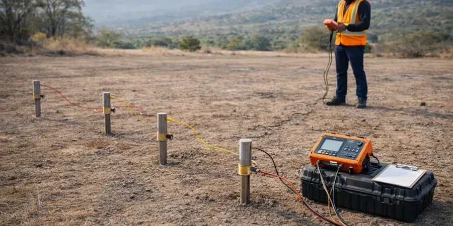
Our approach and scope
Local considerations
Under the National Building Code of Canada (NBC 2020) and CSA A23.3, foundation design must account for variable ground conditions, and in Medicine Hat the rapid lateral changes in Quaternary sediments pose a genuine risk. We have seen sites where the Medicine Hat Sand aquifer pinches out over less than 30 meters, replaced by glaciolacustrine silts with resistivity below 15 ohm-m—a transition that can produce differential settlement if not identified before construction. Overlooking a VES survey in the valley slopes, where ancient landslides have rotated the Bearpaw shale blocks, means the designer may underestimate bedrock depth by several meters and specify the wrong pile length. The clay-rich shale also creates corrosion potential for buried steel; our resistivity data feeds directly into soil aggressivity assessments per the Canadian Foundation Engineering Manual. For structures classified as post-disaster buildings under NBCC, the seismic site classification (Table 4.1.8.4.A) requires shear-wave velocity in the upper 30 meters, and while resistivity does not replace direct Vs measurement, it helps interpolate between CPT soundings and seismic lines, reducing the risk of misclassifying a site as Class C when a thin clay layer actually puts it in Class D territory.
Reference standards
ASTM D6431-18 Standard Guide for Using the Direct Current Resistivity Method, NBCC 2020 Division B Part 4 Structural Design, CSA A23.3 Design of Concrete Structures, Canadian Foundation Engineering Manual (CFEM) 4th Edition
Complementary services
VES Depth-to-Bedrock Mapping
We run Schlumberger array soundings with expanding electrode spreads to determine the depth to the Bearpaw Formation shale. This is the most requested service for foundation design in the city, particularly in the Flats and Riverside neighborhoods where alluvial cover is thick and variable.
2D Electrical Resistivity Tomography (ERT)
Using multi-electrode cables with 56 or 112 takeouts, we image continuous resistivity cross-sections along proposed pipeline routes and slope stability investigation lines. The method resolves lateral changes in stratigraphy that single-point soundings can miss.
Soil Corrosivity & Groundwater Assessment
Measured resistivity values are converted to soil corrosivity ratings per industry standards, supporting buried utility design and cathodic protection planning. We also delineate the water table and identify saline groundwater zones within the Bearpaw Formation.
Typical parameters
Common questions
What does a VES survey typically cost for a residential lot in Medicine Hat?
For a standard residential site requiring two to three Schlumberger soundings with maximum electrode spreads around 100 meters, the cost typically ranges from CA$770 to CA$1,440. The final amount depends on site accessibility, the number of soundings required to cover the lot, and whether topographic correction is needed—common on the sloped lots along the South Saskatchewan River valley.
How deep can resistivity testing investigate in the Medicine Hat area?
The maximum investigation depth is controlled by the current electrode separation (AB/2). With a practical AB/2 of 300 meters, we can reach roughly 200 meters depth, well below the base of the Quaternary sediments and into the Bearpaw Formation. For most geotechnical projects, we target 25 to 50 meters to map the bedrock surface and identify saturated sand lenses within the Medicine Hat Sand aquifer.
Can resistivity distinguish between clay-rich shale and saturated sand?
Yes, and this is one of the main reasons we use the method in Medicine Hat. The Bearpaw Formation shale consistently reads between 3 and 8 ohm-m because of its high clay content and saline pore water. Saturated clean sands of the Medicine Hat Sand typically measure 25 to 60 ohm-m, while the same sands when dry can exceed 100 ohm-m. The contrast is strong enough that we can map the contact with good confidence, though we sometimes cross-check with borehole data or CPT to confirm lithology at key locations.
How does electrical noise from the city affect the measurements?
Medicine Hat’s industrial areas, especially near the power plant and along the CP Rail corridor, produce significant 60 Hz noise and stray currents. Our resistivity meter applies automatic stacking—repeating each measurement multiple times and averaging—plus a notch filter tuned to 60 Hz. Electrode contact resistance is checked before every sounding, and in high-noise environments we switch to a dipole-dipole array, which is less sensitive to telluric and cultural noise than the Schlumberger configuration.
What deliverables do you provide after a resistivity survey?
We deliver a geophysical report that includes the raw apparent resistivity data, processed 1D sounding curves with layered earth models, and 2D resistivity cross-sections with topographic correction applied. Each section is annotated with interpreted stratigraphic boundaries and correlated to any available borehole logs or CPT data. The report also includes electrode location coordinates in UTM NAD83, a description of field procedures, and the quality control metrics from the survey.